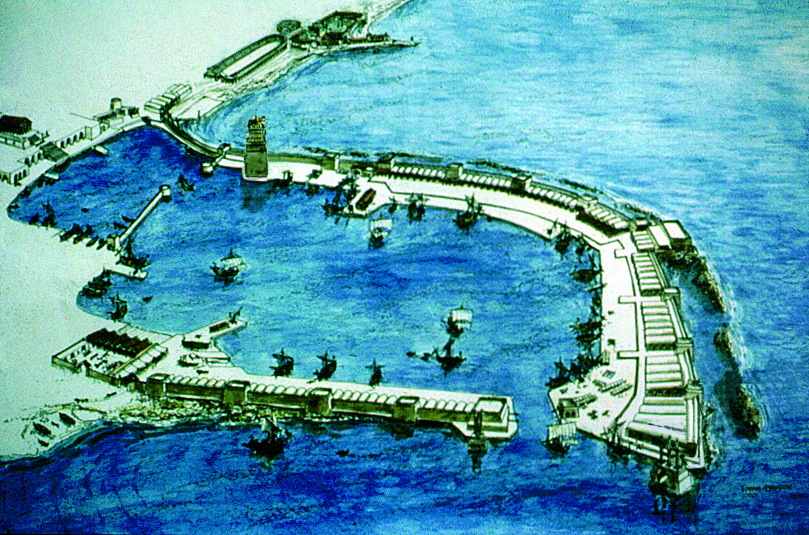
The enclosed anchorage area was about 20 hectars. It consisted of three basins. The inner one was dug inland and today is completely silted up. This basin is marked in the water by a round tower, which may have been a part of the Hellenistic fortifications of Straton’s Tower, the town preceding Caesarea. It is built of ashlar stones arranged in a circle, 13m in diameter, with their narrow side facing out (“headers”). On the tower’s eastern side there is a trimmed block, designed to incorporate a lead water pipe, which brought water in from the shore. The tower is located at the northern entrance to the inner harbour, now land-locked. The eastern quay of this basin may be observed in the small pool below the temple podium, where a bollard and an abrasive line mark the ancient water level. It turns out that this inner basin started silting up right after construction, with many attempts to dredge and keep it functioning. Moreover, permanent building on this site was impossible because of recurrent inundations by the sea. Only in the early Moslem period (8th century AD) a well planned urban quarter was built in this area. It is now mostly covered by grass.
The middle basin was in a natural bay and corresponds to the modern anchorage. A portion of the Herodian pavement of the main breakwater is preserved in situ, just under the modern concrete quay, west of the diving center (6). Ashlar built piers jutted into the port’s basins, increasing the dock area. The external basin, the biggest of the three, was created by the construction of two huge breakwaters, which were the first of their kind in history. The length of the main breakwater and mole, stretching in a large arc from S/E to N/W, was about 500m, and its width at the base was c.60-70m. On the outer edge of the mole was a sea wall with towers at regular intervals, while on the inside there was a quay for loading and unloading, warehouses and a promenade along its entire length. At the southern end of the mole(on the site of todays’s citadel) stood the largest tower – the Drusion – which may also have served also as a lighthouse. Estimates of the original width of the entrance channel range from 30 to 80m. Outside the entrance stood twin towers, marking the way in. The towers were connected at the top by a platform designed to carry magnificent sculpture (that did not survive).
The harbour area was enclosed on the north by a straight, shorter mole, on the end of which the port authority building might have stood. Some of the stone blocks found here were especially fashioned, perhaps to serve as sockets for capstans, which rolled the iron chain closing the harbour entrance in times of need.
Written by Sarah Arenson


